Навигаторы Navitel DN505 MAGNETIC - инструкция пользователя по применению, эксплуатации и установке на русском языке. Мы надеемся, она поможет вам решить возникшие у вас вопросы при эксплуатации техники.
Если остались вопросы, задайте их в комментариях после инструкции.
"Загружаем инструкцию", означает, что нужно подождать пока файл загрузится и можно будет его читать онлайн. Некоторые инструкции очень большие и время их появления зависит от вашей скорости интернета.
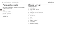

8 |
USER MANUAL — QUICK START GUIDE
EN
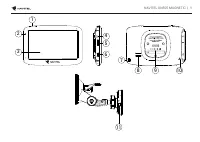
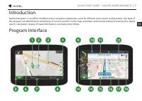
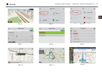
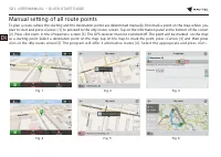
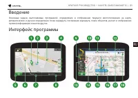
1
Point on the
map
Short tapping on the map marks the point for further operations with it, “Cursor” and “Save WP”.
2
POI
This is an example of how points of interest (POI) are displayed in the program. Different categories of
POI have different icons. There is a large variety of icons for particular POIs such as shopping centers,
brand shops, gas stations etc.
3
SPEEDCAM
This is an example of how icons of the SPEEDCAM function are displayed on the map. Speedcams are
special marks on the map that are meant to warn about speed cameras, radars, dangerous crossroads,
speed bumps, and other types of potential obstacles on the road.
4
Map buttons
These are the buttons for controlling the map view modes (2D/3D), map scaling, and volume settings.
5
Main menu
Tapping this button will open the main menu of the program.
6
Road signs
Warning road signs.
7
Cursor
This button becomes available only when a point is selected on the map. Tapping this button will open
the “My route” screen, where you can carry out various operations with the selected point.
8
Save WP
This button becomes available only when a point is selected on the map. Tapping this button will cause
the selected point to be saved in the form of a waypoint.
9
Upcoming
maneuver
The indication of the distance to the next two upcoming maneuvers. Tapping the sign opens a dialog
box with a number of configuration settings.
10
Progress bar
This bar indicates the elapsed and remaining part of the route. The green cursor is sliding along the
progress bar in order to indicate the distance left to the final point. Not only can the user check the time
left, but also the distance to it.


